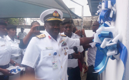
Representative of the CNS and FOC Western Naval Command, Rear Admiral Sylvanus Abbah, commissioning the NNHO data centre and Maritime Safety Information Portal.
By Evelyn Usman
Nigeria, yesterday, fulfilled a critical international Hydrographic requirement, with the establishment of the Maritime Safety Information MSI portal , which will enable prompt information that will aid safe navigation by mariners through the nation’s water and the Gulf of Guinea.

Representative of the CNS and FOC Western Naval Command, Rear Admiral Sylvanus Abbah, commissioning the NNHO data centre and Maritime Safety Information Portal.
Established by the Nigerian Navy , which is the charting authority for Nigeria, the facility , is also expected among other things , to breach the communication gap between mariners navigating through the nation’s waters and the hydrographer in the event of danger .
Speaking at the commissioning ceremony held at the Nigerian Navy Hydrographic office in Apapa , Lagos, the Chief of the Naval Staff , Vice Admiral Ibok Ete- Ibass noted that as a member of the International Hydrographic organizations and other international maritime bodies , Nigeria holds it a responsibility to provide mariners with hydrographic data , that would promote safety and security in her maritime domain.
Represented by the Flag Officer Commanding Western Naval Command, Rear Admiral Sylvanus Abba , he said that with the establishment of the portal, the country had achieved the first phase of the international Hydrographic Organisation’s capacity building, adding that the navy was at the verge of accomplishing the second and third phases, which would make the country self- reliant in providing complete hydrographic service delivery to mariners in the near future.
He said : “ Maritime activities cannot thrive without security and safety , which largely depend on the availability of accurate and timely hydrographic data and information. With our water safe and secured, robust maritime activities will thrive and this , will boost Nigeria’s economy and ultimately improve the general well being of all Nigerians
“ These data can be in form of nautical charts, be it paper and electronic navigational charts, nautical publications, as well as essential navigational warnings about uncharted dangers and other related issues which need to be disseminated quickly, to facilitate safe conduct of maritime activities.
“ I wish to admit that accomplishment of effective maritime safety and security of any nation transcends an individual organization but is borne out of the ability of the entire maritime industry to evolve relatively sustainable safety and security structures to stimulate a robust Maritime Domain Awareness.”.
He therefore, called on all stakeholders in the maritime sector to cooperate and utilize the facility , pointing out that it would ensure timely collation, processing and dissemination of real time navigational warnings and other safety information to mariners operating within Nigeria, as well as ensure that maritime stakeholders download and upload relevant safety and security information for timely dissemination to ships operating with the navy’s area of Responsibility.
Earlier in his welcome address, the Hydrograopher of the Nigerian Navy, Commodore Chukwuemeka Okafor , said that the establishment of the infrastructure was long overdue considering the national role statutorily assigned to the Navy in the field of hydrography.
Noting that the quick and accurate dissemination of maritime safety and other hydrographic information to mariners was central to facilitating safety of navigation and security within the maritime domain, he lamented , that absence of the facilities over the years had led maritime stakeholders to raise concerns both at local and international fora , owing to the availability of limited safety and hydrographic information within Nigeria’s waters.
He said : The facilities are not only intended to provide navigational warnings of uncharted dangers to navigation and meteorological forecasts to mariners navigating within Nigerian waters , it will also enable mariners to easily reach out to the Hydrographer, to report any uncharted features observed during their voyage within the nation’s waters , which may constitute dangers , so that such information can be shared with other mariners through MSI facility.”
He highlighted three basic types of navigational warnings that could be promulgated through the facility as local, coastal and navigational area warnings.
The world according to Commodore Okafor, “ is currently divided into 21 navigational areas with Nigeria under navigational Area 2 which is coordinated by the French hydrographic office , in Breast, France. The accomplishment of the feat is not just a pride to the Nigerian Navy but to all mariners and stakeholders within Nigeria’s maritime domain”, he said .
Disclaimer
Comments expressed here do not reflect the opinions of Vanguard newspapers or any employee thereof.