By Emeka Ezeajugh
The Nigeria Erosion and Watershed Management Project (NEWMAP) was born in 2010 following the request for assistance made by the then President, Dr Goodluck Jonathan to World Bank. NEWMAP is a World Bank assisted project which was aimed at addressing severe mass wasting of soil cover that resulted in numerous gullies and land degradation in the southern and northern parts of Nigeria respectively.
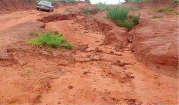
It is estimated that there are over 3000 gully erosion sites in the 10 most affected states in the southeast, south south and southwestern parts of Nigeria, but particularly in the southeast. The most affected areas in southern part of Nigeria are Anambra, Imo, Abia, Enugu, Ebonyi and Cross River States. In Anambra, it is a lesser task to count which communities are not affected by the erosion crisis, rather than the ones that have been impacted by the menace.
Recently, the Anambra State commissioner for Environment, Engr. Felix Odumegwu indicated that over 70% of the state’s landmass is under severe threat of gully erosion. Well, that is how catastrophic the problem is. A disaster of humongous proportion by any standard of measurement.
With financial commitment in the order of US$900.0 million and a target closing date of June 2022, having commenced on the ground about 2012, the ten years is already up, and it is time to look back and evaluate the impact of the program. It is understood that over 1,558.62 hectares of degraded land were reclaimed in its first seven years of the program.
Leveraging on the successes of the program, additional states have been listed to partake in the program. It is also understood that Dr. Sanje Srivastava of the World Bank having given a thumbs up for the NEWMAP has indicated that another program with pseudonym ACRESAL which stands for agro-climatic resilience in semi-arid landscape may continue from where NEWMAP stopped. This is a welcome development and the assistance from the World Bank under whatever pseudonym must be appreciated and should be complimented by the Federal and State governments.
Though the success of NEWMAP has been sung repeatedly, it is a responsibility on the program coordinators to critically assess the outcomes and the way forward with the anticipated ACRESAL or other similar intervention schemes. Whatever the gains of NEWMAP may have been, one would think that the greatest legacy the program would leave behind is capacity building.
That is, the ability of home-grown engineers, surveyors, geologists, conservationists, and other allied disciplines that have participated in the program to have acquired requisite knowledge to tackle such challenges going forward. It is also a responsibility of the program coordinators to monitor the long-term performance of the finished projects. This will enable them to document what works and what does not, as such is a critical part of any project life cycle.
Such learning helps in the design and delivery of future projects. Unfortunately, such learning or performance behaviour has never reflected in the ad-hoc solutions implemented at the Nanka landslide. Peripheral drains that never worked has always come back as a primary remedial solution, hence the monumental loss of materials on the bare walls of the slide.
Based on a 2014 Google image which shows the site with approximate dimensions of 600mm wide at the top and about 105m deep at one of the accessible x-sections and site observations, between Amako Nanka and Oko communities, it was estimated that up to 300,000m3 of materials may have been lost on the Oko face of the gorge after few cycles of rainy season. At the time of the estimate, a failed peripheral drain was discharging runoff directly unto the bare batters of the near vertical faced gorge.
The non-cohesive (friable) nature of the native soils and the high rainfall intensities in the area played into a cocktail of potent variables driving the active landslide status of the site. Shown in the photo below is a half-symmetry view of the exposed near vertical soil columns on the Oko side of the gorge.
stress principles, pore water pressure and soil reinforcement, the mass wasting at Nanka could be turned around for the best. Among numerous opportunities, the space could be turned into a parkland with or without restricted use. Restricted use as parkland, if the State could take advantage of the deep gorge which has truncated the water table for harvesting potable water. A small weir or dam following the reinforcement of the sides of the gorge should be given serious thought.
What of a borehole field, as the groundwater table is shallow as evidenced by the perennial base flow in the gorge? By and large, the site could be recovered and put to good use. It has been left for too long, thereby resulting in what has been hitherto referred to as the ‘mother’ of all erosions.
*Ezeajugh is a Civil Engineer and Geologist. He writes from Brisbane, Australia
Disclaimer
Comments expressed here do not reflect the opinions of Vanguard newspapers or any employee thereof.